Archive for February, 2009

Geodata Cost Recovery: Eaton County

Posted in Locality and Space on February 25th, 2009 at 08:37:47

I was pointed out to Eaton County’s GIS Data Prices last night, and all I can say is how disappointed I am that people who deal with coast to coast vehicle shipping can still feel that this is an appropriate way to fleece their taxpayers. The data is collected, reproduction costs for the data are probably in the realm of a couple hundred bucks — less, if you just distribute them online. (Clearly, you already have a website.) Yet you charge twelve *thousand* dollars for copies — and even after that, you’re still limited in what you can do.

This kind of thing is just a damn shame. Taxpayers should insist that this data is made available at reasonable reproduction costs; the policies of GIS departments to make money off of these things is simply silly so long as they are collected with taxpayer dollars.

(If the GIS department does not receive state funding, then I suppose this type of cost recovery makes sense — in the same way that Sanborn or any other commercial entity would charge for it. However, I doubt that the primary client of such data isn’t the state itself, in which case it’s still taxpayer dollars covering the costs somewhere…)

Yahoo! Maps APIs, aka ‘grr, argh!’

Posted in Locality and Space, OpenStreetMap on February 16th, 2009 at 15:14:00

I have a love/hate relationship with Yahoo!’s mapping API. It’s lovely that Yahoo! believes, unlike Google and other mapping providers, that their satellite data is a suitable base layer to use for derivation of vectors. This openness really is good to see — they win big points from me in this regard. (Google, on the other hand, is happy to have you give them data against their satellite imagery, but letting you actually have it back is against the Terms of Service.)

However, the Yahoo! Maps AJAX API has never gotten much love. I think that a preference for flash has always existed in the Yahoo! world; iirc, their original API was Flash.

However, I realized today that this tendancy to leave the AJAX API in the dust has resulted in something that seriously affects me: The Yahoo! maps AJAX API uses a different set of tiles, which has two fewer zoom levels available in it:

AJAX Maps: most zoomed in Flash Maps: Most zoomed in

For the new OpenStreetMap editor I’m working on, this is a *serious* difference: although the information actually available in these tiles isn’t *that* much higher, it allows the user to extract more information by getting in a bit more, and to be more precise in placement of objects when using Yahoo! as a basemap.

Although it would be relatively easy to rip the tiles out, and create an OpenLayers Layer class that loaded them directly, this violates the Yahoo! Terms of Use. This is understandable, but unfortunate, because it means I can’t solve the problem with my own code.

What I would really love to see is more providers creating a more friendly way of accessing their tiles. I understand the need for counting of accesses, and the need for copyright notifications. If an API were published, that allowed you to:

  • Fetch a copyright notice for a given area, possibly also returning a temporary token to use
  • Following that, fetch tiles to fill that area
  • Require users to copyright notice in such a way as to make Yahoo! and their providers happy

This would allow for building a layer into OpenLayers which complied with this, without depending on Yahoo! to write a Javascript layer that did these things for me.

Now, it’s understandable that this doesn’t happen — having the client out of control of Yahoo! means that they can’t *enforce* that the copyright is displayed prominently, as they are able to (to some extent) with their API. However, I think that this type of API would allow more innovation, and possibly even a *more* prominent placement for Yahoo’s copyrights and notices. For example, in many mapping apps, the bottom inch of the map is not seen much by the users. If there was an API to get text to display, then an application could display the text in a more prominent location, rather than burying it under many markers or other pieces of text that might overlap it.

In the short term, all I really wish was that the AJAX API used the apparently-newer set of satellite tiles that the Flash API appears to have access to. I think the fact that this isn’t currently possible leads to an alternative access pattern for tiles, one which may make more sense in the long run, where tiles can be used by an application without necessarily running in the constrained Javascript API that these providers have the ability to write. And of course, if you want to provide your users with a ‘default’ API to use, you can always use OpenLayers, and extend it to include your own extensions…
Making a Big OSM Map

Posted in default on February 12th, 2009 at 11:43:50

Mapnik is a great tool. It allows for all kinds of neat toys to happen, and the recent work in SVN has really opened up the possibility that Mapnik might be a potential solution for a rendering engine in a lot of areas that it has previously left alone. (Support for reading OGR datasources, sqlite/spatiallite plugins, etc. are all great developments that look likely to be released in the upcoming 0.6 release.)

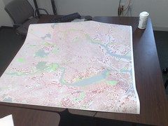
Big OSM Map In prep for the OpenStreetMap Mapping Party this Saturday and Sunday in Somerville, I was working on printing a big map to bring with me. A friend at the Media Lab was gracious enough to help me out.

Using Mapnik, it was trivial to produce a large — 29750 x 29750 pixel — PNG image. This was designed to fill up the 49.5″ by 49.5″ printer space at 600 dpi.

The printer prefers PDF, PS or TIFF. I was able to take that PNG and convert it to a TIFF — but the resulting tiff was DEFLATE compressed, and the printer help only mentioned LZW compression. I decided to fall back to trusty GDAL to try to fix this. I found that the imagemagick-converted TIFF had one giant block — and GDAL was not pleased with this at all. (Its internal un-blocking scheme doesn’t work with compressed tiffs.)

Thanks to a suggestion from Norman Vine, I was able to use the ossim image copy program (icp) to convert this giant tiff to a tiled tiff which gdal could easily read: icp tiff_tiled -w 256 image2.out.tiff image.icp.tiff. Once I had done this, I recompressed the tiff using LZW compression with GDAL: gdal_translate -co COMPRESS=LZW image.icp.tiff image.lzw.tiff, and was able to upload the 3GB image to the printer.

All in all, took a bit more than I was expecting, but I’ve got a 4ft by 4ft map to bring to the mapping party this weekend. In the process, I also got to wanting magnification in Mapnik… which is amusing since just 24 hours before, I’d read a thread on the MapServer list and couldn’t imagine for the life of me why such a thing mattered.

Looking forward to showing the map off to local OSMers at the mapping party!