Archive for the 'OpenAerialMap' Category

OpenAerialMap Project Update

Posted in Locality and Space, OpenAerialMap on December 18th, 2008 at 20:24:06

For the past 6 months, the OpenAerialMap project has been in a state of … well, stagnation would be a nice way to put it. I’ve just sent an email to the mailing list Outlining the status as I see it, and I would love to see feedback and opinions on the list.

The biggest problem with OAM is that it never developed a community around it. My hope is that with an increase in interest in the past $shortWhile, there is sufficient interest to build a community this time around, and with that, enable the project to succeed in a way that it couldn’t 6 months or a year ago.

Producing a Large Image from OpenAerialMap

Posted in FWTools, GDAL/OGR, Locality and Space, OpenAerialMap on December 9th, 2007 at 05:01:44


One of the things that users often want to do within MapServer or other tools is to hook up to existing caches of high resolution aerial imagery, like VirtualEarth, Google, etc. to get an aerial basemap that is as high resolution as possible, preferably for free. This applies to cases other than serving web maps as well: for example, the EVS Islands blog has been using Google Earth imagery to derive datasets from for some time now, and is now acting as if there is a product that Digital Globe is selling which could fill this need.

Of course, many users also want a pony.

In some cases, the imagery you see in Google Earth is something you can’t even buy for use online — so with all the money in the world, you might find yourself short a high resolution dataset, or so you might think.

It turns out that for some areas of the world, there is a lot of *public* imagery available. Instead of depending on commercial providers, and the restrictions they entail, you can turn this free datasource into a source for your own maps. OpenAerialMap has begun the task of collecting and collating these images for you, so you don’t have to have your own WMS to see the latest data from the USGS dataset in your maps. (It’s still in its early stages, but it’s getting there.) Now, I understand that in the less enlightened parts of the world, this is not yet the case, but we’re getting there, slowly but surely.

But what happens when you don’t want a map, but instead want an image that you can include in your print-resolution magazine spread?

Open Source Software happens, that’s what.

GDAL has the ability to read images from a remote WMS server, and treat them as it does any other data source: which means that it can take the images, and convert them to any other format, from JPEG2000 to GeoTIFF. And it doesn’t even require any system dependencies for Windows or Linux: Just use Frank Warmerdam’s excellent FWTools. FWTools wraps up all the tools you need to work with geographic formats, be they raster or vector, into one neat package.

  1. Grab FWTools: Linux, Windows
  2. Unpack/extract it.
  3. Run the install script in the root directory.
  4. Grab http://openaerialmap.org/static/gdal_wms.xml and save it to the root of your FWTools installation.
  5. Open a command line prompt in the FWTools directory.
  6. Type: bin_safe/gdal_translate -projwin -93.246226 44.892179 -93.195672 44.866816 -outsize 9424 4728 -of JPEG gdal_wms.xml airport.jpg

End result? A 10000 by 5000 mosaic of the Minneapolis-St. Paul International airport, using data loaded from Public Domain USGS aerial imagery — some from Ramsey County, some from the Twin Cities overflight, both higher than 1M resolution (.15 and .3 respectively) within the past year and a half — and the speed to create it is essentially as fast as your connection to the net.

You can try this at home, and once you have the image, you can do *whatever you want with it*: The data involved is all public domain, and there is nothing to stop you from doing anything with the data. You can convert it to another format, derive vectors from it, print it out on a giant poster board, etc. No attribution or other sourcing necessary, because the data is public.

OpenAerialMap is all about the sharing of data that you should be able to get access to anyway, and as you can see here, in some cases the data that you wish you had you have access to already — you just didn’t know it yet.

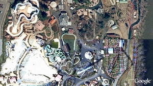
GE vs. OAM

Posted in Google Earth, OpenAerialMap on December 6th, 2007 at 14:18:54

Google’s imagery vs. the imagery in OpenAerialMap:

GE Snapshot

Which one is which?

The answer is probably obvious from the OAM Main Map, once you know where to look…

This is a case where I actually like OAM’s imagery better than GE’s. I’m pretty sure both are sourced from MassGIS, but GE’s is from 2003, and OAM’s is the more recent 2005 imagery.

OpenAerialMap: Google SuperOverlay

Posted in KML, Locality and Space, OpenAerialMap on December 6th, 2007 at 02:53:26

One of the things I forgot about in my previous post: TileCache now has “superoverlay” support for some limited cases, and OAM is the first real test case of that. You can check it out by downloading OAM KML and offer any feedback to me.

I’ve actually found myself very disappointed with this support: It seems that Google downloads all the tiles in series, with no parallelization. The end result is that it takes *forever* to actually get down to an area, though I think I’ve worked out a solution that will make that much better (at the cost of sometimes dropping out the OAM images before the next layer is ready to display).

So, if you’re a Google Earth user, and want to see what OAM is all about, grab the KML above and start spinning the globe around.

OpenAerialMap: Using with Other Tools

Posted in GDAL/OGR, Google Maps, Locality and Space, OpenAerialMap on December 6th, 2007 at 01:57:12

One of the cool things about building a map on top of quality Open Source products is the ease with which one can extend the possible uses of your software.

GDAL 1.5 has gained the ability to read a WMS-C style remote tile cache directly: this means that any tool which uses GDAL as an image provider can read remote tile caches directly. The one that matters the most to me is MapServer: MapServer has the ability to load up a simple config file — http://openaerialmap.org/static/gdal_wms.xml — and use that in a mapfile: Using With MapServer.

Not running the bleeding edge GDAL? That’s fine: Instead, you can use the WMS that’s hosted by the OAM project: Using With WMS. This means that any WMS client — including those fancy schmancy ESRI tools that speak WMS. (There are at least some of them, I think.)

Your application only speaks in WorldWind? Well, we can take care of that for you: With a WorldWind metadata file, you should be up and running in no time. (In my experience, unfortunately, this is true in ossimPlanet, which has no problem with the file, but WorldWind itself seems a bit touchy about it once you zoom past the first couple levels. But I can only do so much.)

Using the new plugin-friendly TileCache that I rewrote last night, I was able to add support for the Mobile GMaps client — Using With MGMaps — in just 20 minutes. Similarly, a user reported success using the tiles with Maemo Mapper.

Of course, it can be used with OSM — either as a tile backdrop, or in the OSM editing application (JOSM): Using With OSM — due to the above plus TileCache’s TMS support.

As a result of the TMS support, it should be possible to load into Google Maps as well, though I’m really too lazy to test that one.

Overall, with just a few small tools — GDAL, MapServer and TileCache — it’s possible to build support for a wide variety of services from a single dataset.

OpenAerialMap Prorotype

Posted in Locality and Space, OpenAerialMap on November 26th, 2007 at 11:38:40

Prototype of a worldwide seamless multi-resolution baselayer powered by open data:

OpenAerialMap